
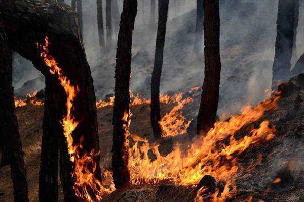
The Zabarwan Hills have long been part of Srinagar’s identity. Rising above Dal Lake, their forests soften the city’s skyline, shelter wildlife and protect slopes that are as ecologically fragile as they are visible. Yet in recent years, the same hills have repeatedly revealed another face, dry ridgelines glowing with fire, smoke drifting across the valley and emergency crews struggling to reach terrain never designed for rapid intervention.
Each blaze is more than an isolated forestry incident. It exposes a wider vulnerability in Kashmir’s approach to environmental risk, one that places too much weight on emergency response and too little on prevention. The question is no longer whether the Zabarwan can burn, it can, and it has. The question is whether Kashmir will invest in the early warning, planning and coordinated action needed to stop the next spark from becoming a catastrophe.
The terrain makes management unusually difficult. Steep slopes, exposed ridges, dense vegetation and limited access complicate firefighting. In dry spells, fallen leaves, grasses, dead branches and forest litter become highly combustible and in pine-dominated patches, fallen needles ignite readily. Once flames reach the canopy or race across a ridge, containment becomes far harder. Fire engines cannot reach every slope, and trained personnel must often approach on foot with beaters and rakes. Seasonal preparedness is therefore essential.
Across Jammu and Kashmir, the main forest-fire season generally runs from March to June, with April and May often the riskiest. Yet danger does not vanish outside these months, prolonged autumn dryness, scant rainfall and strong winds can leave slopes exposed.
Vigilance must follow local weather, vegetation and fire-danger assessments rather than the calendar alone. Human activity can turn these conditions into disaster. An unattended campfire, a discarded cigarette or agricultural waste burned near a forest boundary may be enough to start a blaze. Every incident should be investigated, but preventing avoidable ignitions remains among the most practical ways to reduce risk.
The Forest Department, through its field staff and the Forest Protection Force, is central to patrolling, detecting fires, maintaining fire lines and leading suppression. The Wildlife Protection Department must safeguard protected areas, while Fire and Emergency Services can help where settlements are threatened. In major incidents, the district administration, police and disaster-management authorities must coordinate personnel, communications and access. No single agency can manage a major fire in isolation. Effective response depends on clear responsibilities, rapid communication and the ability to mobilise trained personnel before flames spread beyond control. In mountains, even a short delay between detection and deployment can turn a manageable incident into an emergency.
Prevention must begin weeks or months before the most dangerous conditions arrive. Vulnerable slopes should be mapped, equipment inspected, communication networks tested and access routes assessed. Existing fire lines must be maintained where ecologically appropriate and patrols strengthened during high fire danger. Public warnings, restrictions on open flames in vulnerable locations and prompt investigation of suspicious ignitions should form part of a coordinated plan.
Communities near forest-facing settlements should know reporting procedures and seasonal risks, their role is awareness, observation and early reporting, not confronting dangerous fires without training or protective equipment. Science can make these efforts more effective. Fire-danger rating systems combine weather, humidity, wind and fuel conditions to estimate how likely and how intense fires will be, helping officials prioritise patrols and position personnel. A locally calibrated system could identify the Zabarwan’s most vulnerable slopes during prolonged dry weather and direct resources there before an emergency develops.
Technology is also contributing. The Forest Survey of India uses satellite observations from NASA’s MODIS instruments and the VIIRS sensor aboard the Suomi NPP satellite to identify potential hotspots and shares detections with forest authorities through electronic alerts, including SMS. Alerts arrive several times daily. Yet satellite alerts are not a substitute for ground surveillance. A detection may be a thermal anomaly rather than a confirmed fire and small fires can develop between satellite passes.
FSI itself advises using satellite information alongside other detection methods. The next step is to ensure these tools translate into faster action on the ground. Satellite alerts, field reports, weather data and mapped access routes should feed into a common operational system, so officials can locate a fire, verify the report and dispatch the nearest crew without delay.
Cameras with smoke-detection software, thermal imaging and drones could add capability, but only after pilot projects and never as substitutes for trained staff or reliable communications.The United States offers lessons. NOAA’s Next Generation Fire System uses geostationary satellite data and automated algorithms to identify potential fires rapidly. The lesson is not that every American technology should be imported, but that early detection becomes far more valuable when integrated with local verification, trained response teams and dependable communication.
A sophisticated alert system is of little use if no one can reach the affected slope. Uttarakhand offers a more relevant example. Its mountainous terrain and recurring fires have prompted dedicated reporting systems, watchtowers, crew stations, wireless networks and fire-line maintenance, alongside an emphasis on community participation. Van Panchayats, locally based forest-management bodies, give residents a stake in protecting forests tied to their livelihoods. People living near vulnerable slopes know the access routes and can report smoke early, with training and equipment, comparable networks could strengthen reporting around the Zabarwan.
Australia offers a different lesson through Indigenous cultural burning, where Aboriginal knowledge holders and park managers in places such as Kakadu use carefully timed, low-intensity burns to reduce combustible vegetation and limit later, more intense fires. This should not be copied mechanically, Himalayan forests differ substantially, and fire can escape control in unsuitable conditions. Any prescribed burning in the Zabarwan would require scientific assessment, trained personnel, suitable weather, legal authorisation and a containment plan.
The consequences of a fire extend far beyond lost trees. Flames destroy wildlife shelter, damage feeding and nesting habitats and force animals towards settlements, while lost vegetation exposes soil to erosion and increases runoff. Smoke can harm people below the slopes, particularly those vulnerable to respiratory and cardiovascular illness, because the range lies so close to Srinagar and Dal Lake, its degradation is an issue of environmental security, not merely forestry.
After a fire, restoration must be guided by ecological evidence rather than a rush to plant trees. Some areas may recover naturally, others may need soil stabilisation, protection of regeneration or control of invasive vegetation. Authorities should first assess fire severity and soil condition. Ultimately, Kashmir needs a strategy that measures success not only by how many fires are extinguished, but by how many are prevented, how quickly incidents are detected and how well damaged ecosystems recover. That requires sustained funding, trained personnel, functioning equipment, reliable technology, public cooperation and clear accountability across departments.
When the smoke clears, Srinagar may return to its familiar rhythm, but scorched slopes remain a reminder of the cost of delayed action. Kashmir can reduce avoidable ignitions, strengthen early-warning systems and ensure those responsible for protecting the forest are ready before danger arrives. The real triumph will not be helicopters above a burning ridge or exhausted crews returning after a night of firefighting. It will be the fire that never starts, the smoke detected before flames spread and the forest that survives another season because prevention began in time. The Zabarwan Hills have stood above Srinagar for generations, protecting them now demands less dependence on emergency heroics and greater investment in science and preparedness.
The writer is a Businessman. mauzambakshi@gmail.com