
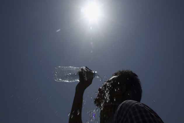
Srinagar: Srinagar recorded the season’s highest temperature on Monday as the mercury soared to 35.3 degrees Celsius, 5.3 degrees above normal, with the Meteorological Department forecasting another day of intense heat before rain is expected to bring relief from Wednesday.
According to the Meteorological Centre, Srinagar, heatwave conditions are likely to persist till Tuesday, while an approaching Western Disturbance is expected to trigger light to moderate rainfall across Jammu and Kashmir from July 1.
Several other parts of Kashmir also witnessed unusually high temperatures. Qazigund recorded 33.8°C, around 5°C above normal, while Kokernag registered 32.9°C. Kupwara recorded 32.7°C, Pahalgam 29°C and Gulmarg 26.2°C, more than 5°C above the seasonal average.
In contrast, temperatures across the Jammu division remained close to normal under monsoon-like conditions. Jammu city recorded 36.9°C, while Banihal, Batote, Bhaderwah and Katra recorded temperatures ranging between 29.3°C and 35.6°C.
The weather office said daytime temperatures in Kashmir are expected to remain 4°C to 8°C above normal on Monday, with generally hot and dry conditions during the day. However, light rain or brief thundershowers accompanied by gusty winds are possible at scattered places later in the afternoon or evening.
From July 1 to July 5, the MeT Department has forecast light to moderate rain and thundershowers at many places across Jammu and Kashmir, with isolated heavy rainfall likely on July 2 and 3.
The department warned that heavy rainfall in parts of the Jammu division could trigger flash floods, landslides, mudslides and temporary waterlogging in low-lying areas. People have been advised to avoid streams, nallahs and landslide-prone areas during the wet spell.
The soaring temperatures affected normal life in Srinagar, with roads, markets and public places remaining largely deserted during the afternoon as many people stayed indoors to escape the heat.
Meteorological officials said temperatures are expected to decline gradually from Wednesday, with more noticeable relief likely from Thursday as the rain-bearing system becomes active over the region.


