
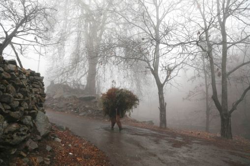
Srinagar: As the 40-day harshest winter period in Kashmir started on Tuesday, the minimum temperature settled well below the freezing point across the Valley, officials said.
Srinagar recorded a low of minus 2.8 degrees Celsius on Monday night, slightly up from minus 5.8 degrees recorded the previous night.
The city had recorded a low of minus 6 degrees Celsius for two consecutive nights on Saturday and Sunday, which was the lowest of the season so far.
Gulmarg resort in north Kashmir’s Baramulla district recorded a low of minus 5 degrees Celsius.
The officials said Pahalgam resort in south Kashmir’s Anantnag district recorded a low of minus 3.7 degrees Celsius.
The minimum temperature in Kupwara in north Kashmir settled at a low of minus 3.8 degrees Celsius.
Qazigund, the gateway town to the Valley, recorded minus 2.6 degrees Celsius, while Kokernag also recorded a low of minus 3.3 degrees Celsius.
The weather office has forecast colder nights over the next couple of days as further fall in the minimum temperature is expected.
There is also a possibility of light to moderate snowfall from December 22-25.
‘Chilla-i-Kalan’ (big cold), which started today, is the 40-day harshest winter period when a cold wave grips the region and the temperature drops considerably leading to the freezing of water-bodies including the Dal Lake here as well as the water supply lines in several parts of the Valley.
The chances of snowfall are the most frequent and maximum during this period and most areas, especially in the higher reaches, receive heavy snowfall.
‘Chillai-Kalan’ will end on January 31. The cold wave continues even after that in Kashmir with a 20-day-long ‘Chillai-Khurd’ (small cold) and a 10-day-long ‘Chilla-Bachha’ (baby cold).


