• About us
  • Contact us
  • Our team
  • Terms of Service
Sunday, August 10, 2025
Kashmir Images - Latest News Update
Epaper
  • TOP NEWS
  • CITY & TOWNS
  • LOCAL
  • BUSINESS
  • NATION
  • WORLD
  • SPORTS
  • OPINION
    • EDITORIAL
    • ON HERITAGE
    • CREATIVE BEATS
    • INTERALIA
    • WIDE ANGLE
    • OTHER VIEW
    • ART SPACE
  • Photo Gallery
  • CARTOON
  • EPAPER
No Result
View All Result
Kashmir Images - Latest News Update
No Result
View All Result
Home Latest News

Coastal Odisha receives heavy rain as severe cyclone ‘Dana’ approaches

Press Trust of india by Press Trust of india
October 24, 2024
in Latest News
A A
0
Cyclone Titli weakens into deep depression; Odisha rivers in spate

File photo

FacebookTwitterWhatsapp

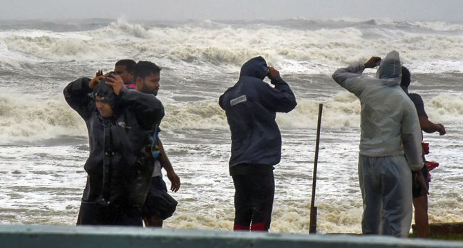
BHUBANESWAR: The coastal belt of Odisha experienced heavy rain and squally winds on Thursday morning with the sea condition remaining rough, as severe cyclonic storm ‘Dana’ approached closer to the state’s coast, the IMD said.

The cyclone is likely to make landfall between Bhitarkanika National Park and Dhamra Port in Odisha early Friday with wind speeds of up to 120 kilometres per hour (kmph), it said.

Related posts

Decades of injustice against tribals in J&K ended in August 2019: LG Sinha

LG payd tributes to brave hearts

August 9, 2025
Nomination of 35 candidates rejected for first phase of J&K Assembly polls

EC delists 334 registered unrecognised political parties for failure to follow norms

August 9, 2025

The weather system over the Bay of Bengal moved north-northwestwards with a speed of 12 kmph during past the six hours, and lay centred about 260 km southeast of Paradip (Odisha), 290 km south-southeast of Dhamra (Odisha) and 350 km south of Sagar Island (West Bengal) at 5.30 am.

“It is very likely to move northwestwards and cross north Odisha and West Bengal coasts between Puri and Sagar Island close to Bhitarkanika and Dhamra during midnight of 24th to morning of 25th October as a severe cyclonic storm with a wind speed of 100-110 kmph gusting to 120 kmph,” it said in the latest bulletin.

The highest rainfall of 62 mm was recorded at Paradip, while Rajnagar in Kendrapara district received 24 mm rain, in the last four hours, the Met Department said.

Moderate to intense rain and thunderstorms with wind speeds of 30-40 kmph are likely to lash some parts of Bhadrak, Balasore, Jajpur, Cuttack, Khurda, Jagatsinghpur, Kendrapada and Puri districts during the day, it said.

Director of the Regional Meteorological Centre, Bhubaneswar, Manorama Mohanty said: “The severe cyclonic storm is likely to re-curve slightly towards west and west-southwards after landfall, triggering rain in southern Odisha around October 26. However, the landfall and wind speed predictions remain unchanged.”

Meanwhile, roads in some areas of Balasore, Bhadrak, Bhitarkania and Puri were blocked, after trees were uprooted due to strong winds, officials said.

Previous Post

PM Modi hails ITBP on its raising day

Next Post

Cop injured as grenade goes off in Baramulla court’s evidence room

Press Trust of india

Press Trust of india

Next Post
“Arrested militant killed in grenade attack”

Cop injured as grenade goes off in Baramulla court’s evidence room

Leave a Reply Cancel reply

Your email address will not be published. Required fields are marked *

ePaper

  • About us
  • Contact us
  • Our team
  • Terms of Service
E-Mailus: kashmirimages123@gmail.com

© 2024 Kashmir Images - Designed by GITS.

No Result
View All Result
  • TOP NEWS
  • CITY & TOWNS
  • LOCAL
  • BUSINESS
  • NATION
  • WORLD
  • SPORTS
  • OPINION
    • EDITORIAL
    • ON HERITAGE
    • CREATIVE BEATS
    • INTERALIA
    • WIDE ANGLE
    • OTHER VIEW
    • ART SPACE
  • Photo Gallery
  • CARTOON
  • EPAPER

© 2024 Kashmir Images - Designed by GITS.