
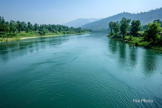
RTI reveals no silt clearance in Kashmir’s main river since 2020; experts warn of looming disaster
Srinagar: Kashmir’s most vital waterway, the Jhelum River, and its associated flood spill channels have not undergone any dredging or silt clearance in the last five years, raising serious concerns among environmental experts and civil society.
The revelation came through a Right to Information (RTI) response filed by noted environmentalist M.M. Shujah with the Irrigation and Flood Control Department.
In its written reply, the department admitted that no dredging work was carried out between March 2020 and March 2025 in any section of the Jhelum or its flood spill channels. This prolonged inaction has heightened worries, especially as climate change and increasingly erratic weather patterns continue to amplify flood risks in the Valley.
Following the devastating 2014 floods, the Government of India approved a Comprehensive Flood Management Plan (CFMP) under the Prime Minister’s Development Package. The plan aimed to enhance Jhelum’s water carrying capacity, remove silt and encroachments, and build embankments and flood defenses.
However, as per the department’s own claims, only 80 percent of the project has been completed to date. The remaining work has been delayed due to funding issues, technical challenges, and administrative inertia.
Experts believe that without systematic dredging and regular maintenance of flood channels, the Valley remains vulnerable to another catastrophic flood event.
The last major “capital dredging” effort took place before 2020, carried out by a Kolkata-based private company, Reach Dredgers. Since then, no new contract has been signed to continue or expand the work.
While the department claims that 670 kilometers of irrigation canals were cleaned during the 2023–24 financial year, yielding the removal of 2.9 lakh cubic meters of silt, experts argue that such efforts were limited to canal networks and did not address the core issue — the silted and narrowed stretches of the Jhelum itself.
The RTI response also disclosed that massive encroachments continue to obstruct the natural flow of the river. As of 2025, the following remain along the Jhelum’s banks: 6.32 lakh (632,000) trees, 1,884 unauthorized constructions, 283 concrete walls.
These obstructions are considered significant impediments to water flow and pose a direct threat during high-discharge periods, especially during the monsoon.
Interestingly, at some stretches, the carrying capacity of the river has technically increased. For instance, between Sangam and Padshahi Bagh, the flow capacity rose from 31,800 cusecs to 41,000 cusecs. However, experts caution that this is not sufficient to prevent flooding, especially when encroachments and lack of silt clearance are not addressed.
Environmental experts have repeatedly suggested the construction of three major dams one each in South, Central, and North Kashmir to store excess floodwater. Such infrastructure, they argue, would not only mitigate flood risks but also support agriculture and enable hydroelectric generation.
“With increasingly unpredictable rainfall and climate shifts, the Valley is staring at a potential repeat or even a worse version of the 2014 floods,” experts warned.
As Kashmir braces for another monsoon cycle, the absence of preventive infrastructure and delayed action continues to leave millions of residents vulnerable to natural disasters.
224 houses damaged by cloudbursts in Kishtwar
As many as 224 residential houses were damaged in the recent cloudbursts in the Marwah and Warwan sub-divisions of the Kishtwar district, Jammu and Kashmir, on August 26, an official said on Sunday.
Of the 224 houses, approximately 50 were destroyed, 140 were severely damaged, and the remaining houses suffered partial damage, the official spokesman mentioned, as Deputy Commissioner Kishtwar Pankaj Sharma, along with Senior Superintendent of Police Naresh Singh, visited the affected villages.
The spokesman noted that around six to seven locations across Marwah and Warwan were hit by cloudbursts, which also damaged roads and bridges.
During his visit to the severely affected Margi village, Sharma directed the Revenue Department, SDRF, and other teams to prioritise the clearing of debris from around the houses, the spokesman said.
In light of the ration stocks that were washed away and were meant to last through November, the deputy commissioner instructed the Department of Food, Civil Supplies & Consumer Affairs to provide a month’s worth of rations to the affected families on an urgent basis, which was provided on the spot.
Relief material from the Red Cross was also distributed among the people, the spokesman said.
The Agriculture and Horticulture Departments were asked to assess losses of crops and fruit trees to ensure due compensation to farmers, the official noted, adding that the deputy commissioner also reviewed the loss of cattle, as 45 animals were buried under debris.
On his directions, tractors and labourers were immediately arranged, and work for the proper disposal of the carcasses began to prevent the spread of diseases in the village, the spokesman said.
Veterinary doctors were also summoned to vaccinate and treat the surviving animals.
The deputy commissioner directed the Public Health Engineering Department to restore the damaged water pipelines and ensure a safe drinking water supply to the affected families, the spokesman said.
Responding to public demands, Sharma assured that a team from the Hydraulic and Irrigation Flood Control Department would soon visit the area to establish long-term protective measures.
Additionally, the deputy commissioner and the SSP held a public darbar in Nowapachi, where locals raised concerns regarding health, education, irrigation, and other issues, the spokesman said.
Sharma assured the community that the district administration would make every effort to provide relief, rehabilitation, and safety measures for the families affected in Marwah and Warwan. (PTI)
Kishtwar faces threat of glacial lake outburst floods, warns report
Glacial lake outburst leading to floods is a serious threat for Kishtwar district, a comprehensive risk assessment has stated, warning that it puts lives, infrastructure, and the fragile ecosystem in grave danger.
According to the GLOF (Glacial Lake Outburst Flood) Management Plan for Kishtwar 2024-25, the tehsils of Padder, Machail, Dachhan, Marwah, and Warwan are in peril of being the worst-affected due to their proximity to glacial lakes.
The report notes that these regions, along with the Kishtwar High Altitude National Park, remain highly vulnerable to sudden flooding.
“These regions are especially vulnerable due to their proximity to glacial lakes, making them prone to sudden flooding events that can have devastating impacts on local communities, infrastructure, and the environment,” the report cautioned.
The danger is not theoretical.
Chishoti village in Padder tehsil, the last motorable stop en route to the Machail Mata temple, was ravaged by a cloudburst-triggered flash flood on August 14 during the yatra, killing 65 people and injuring over 115.
The report underlined that critical infrastructure such as roads, schools, hospitals, and government buildings in these tehsils are “at considerable risk”.
“The tehsils of Marwah and Warwan, often designated as ‘Shadow Areas’ due to their remoteness, house low-lying settlements and agricultural communities that face increased vulnerability due to limited disaster preparedness and emergency response capacities,” it added.
Hydroelectric projects under CVPPL Limited, including the Pakal Dul, Kiru, Kwar, and Dangduru, are also susceptible to high risks. “Rising water levels or potential dam breaches could threaten project infrastructure, disrupt operations, and increase downstream flood risk,” the report said.
It highlights major vulnerabilities across four tehsils of the Kishtwar district due to the threat of glacial lake outburst floods.
The report highlighted significant ecological concerns as well.
“Contamination of local water sources due to floodwaters could further impact public health and ecological balance,” it said, while warning of potential habitat loss and biodiversity threats in the Kishtwar High Altitude National Park.
Two lakes — Mundiksar and Hangu — have been classified as high-risk, while Palta Pani and another unnamed lake have been categorised as moderate-risk.
Explaining the scientific basis of the warning, the report said, “The presence of multiple glacial lakes at varying elevations and their proximity to each other heightens the risk of outburst floods, which could be triggered by factors such as rapid ice melt, landslides, or seismic activity.”
Kishtwar, located in the Western Himalayas, has 197 glacial lakes — the highest in Jammu and Kashmir — and accounts for over one-third of all such lakes in the Union Territory.
Many of these are small, but recent decades have seen a rapid expansion due to climate change, the report said.
“The accelerated retreat of glaciers, driven by rising temperatures, has resulted in the formation and expansion of several glacial lakes in the region, increasing the risk of GLOFs.”
The report called for immediate mitigation measures, including continuous monitoring, early warning systems, drainage and reinforcement of moraine dams, risk mapping, and community preparedness. “Local communities in Kishtwar must be educated about the risks of GLOFs and trained in emergency response,” it stressed.
About long-term strategies, it recommended climate-resilient construction, afforestation to stabilise slopes, and sustained research and development on glacial dynamics. It also suggested earmarking a portion of District Planning and Development Council funds specifically for GLOF preparedness.
“Our commitment to safeguarding lives and infrastructure against GLOFs reflects a broader vision of building a resilient future for Kishtwar,” the plan said.
“Through sustained efforts, we can significantly mitigate the risks posed by natural hazards and foster a safe, secure environment for current and future generations,” it added. (PTI)


